Jessica Thompson
In the influential text Beyond Locative Media published in 2006, Marc Tuters and Kazys Varnelis contextualized a growing body of artworks that used locative apparatuses to generate situated experiences in public space.[1] Written following the ‘demise’ of net.art, the text also sought to address criticisms that locative media was both structurally insular and politically naive. While the ‘media’ of locative media is no longer novel, the significance of early experiments with geotagged content, mobile storytelling, and networked interaction not only lies in their critical use of new technologies, but also in the ways that locative media’s tactics have expanded to reflect the spatial, social, and political dimensions of ubiquitous computing. This paper will examine locative media through the lens of its early trajectories and will explore how the access to data afforded by geospatial technologies provides rich opportunities for politically engaged artistic practice.
Tuters and Varnelis organized locative media artworks into two broad categories: annotative artworks that enable audiences to virtually contribute content, and phenomenological artworks that trace the locations and actions of subjects. While these early artworks integrated available digital tools, such as websites, PDAs, and mobile phones, their significance lies in their invention of new methods of production and dissemination that paralleled, or anticipated, emerging trajectories in new technologies. Mark Hansen and Ben Rubin’s Listening Post (2001) is an important early example of how algorithms derived from user-generated content can be used to animate physical space.[2] A room-sized installation consisting of 231 small text displays, the artwork captured, live and in real time, thousands of conversations happening in chat rooms and transcoded them into generative poetry. The piece cycles through seven audiovisual movements, each with its own processing logic. Words and phrases taken from the data are then ‘sung’. In a paper from 2002, the artists explained that the goal of the work was to capture the ‘buzz’ of chat rooms that could not be experienced by any one participant on their own:
Taken together, public online communications represent an enormous outpouring of real-time data, and this data is filled with complex structure. Topics emerge in response to current events and daily activities in cycles that vary hour to-hour, day-to-day, and season-to-season. The emergence of these topics transcends the boundaries of the online landscape: a local knitting circle in Australia and a political discussion group on Yahoo may both react to news of a political scandal or a world cup victory. Our goal is to distill the content and the structure of this collective communication and to present it in ways that are accessible and compelling.[3]
Other artists reconsidered aspects of Situationist practice, such as psychogeography and the dérive, to create participatory experiences within public space through the creative use of mobile technologies. Works such as [murmur] (2003) and Yellow Arrow (2004) invited users to contribute stories and messages that could be experienced in public spaces.[4] In the case of [murmur]—a community-based mobile storytelling project by Shawn Micallef, Gabe Sawhney, and James Roussel—passersby called a phone number posted on a sign emblazoned with a green ear to be told a story about the location where they were standing.
![]()
Brian House (with Christopher Allen and Jesse Shapins), Yellow Arrow, 2004. Photo by Jesse Shapins.
Yellow Arrow—a collaborative social mapping project created by Brian House, Christopher Allen, and Jesse Shapins—consisted of hundreds of uniquely coded arrow-shaped stickers that were eventually distributed in over thirty countries worldwide. Participants were invited to tag the arrows by sending a text message to a central number, entering their arrow’s code and a message, and then sticking the arrow wherever they wanted. Whoever found the arrow next and texted the number and code would then receive the original message. Created prior to Google Maps, Flickr, and Facebook, the piece functioned as a distributed ad-hoc social network, providing ordinary citizens with opportunities to annotate spaces with their own content, and passersby with opportunities to discover that content through their mobile phones. The piece was also used to facilitate other initiatives, such as an audiovisual tour of the hardcore scene in Washington, DC, a project in Berlin documenting vanished nightlife, and alternative art exhibitions during Art Basel. The distribution of the project was bolstered by television coverage, which, along with blogs, began to disseminate locative media to a mass audience.
Other ‘phenomenological’ artworks use early GPS technologies to trace the movements of the body in public spaces. According to Tuters, by ‘adopting the mapping-while-wandering tactics of the dérive, tracing-based locative media suggest that we can re-embody ourselves in the world, thereby escaping the prevailing sense that our experience of place is disappearing in late capitalist society’.[5] Amsterdam RealTime (2002), by Esther Polak, traced the everyday movements of seventy-five volunteers in Amsterdam in 2002, and transmitted the data via a custom ‘tracer unit’ designed at the Waag Society. The data then appeared as white lines on a black background, rendering the city as a mass of criss-crossed trajectories. The artist describes the map as having the ‘distinct look and feel of psychogeographic experience: it is not precise or rational, but expresses the intuitive and personal aspects of geography’.[6] Teri Rueb’s Drift (2004) is a locative sound walk that takes place along the tidal flats of the Watten Sea in Cuxhaven, Germany.[7] This pioneering work used GPS and custom software housed in PDAs to situate mediations on wandering, walking, and being lost. Situated over a 2 km x 2 km area, the piece drifts from the flats into the town during high tide, generating a spatial dialogue between listeners who encounter the piece through drifting, and the drift that encounters the listener.
While initial categorizations of locative media are useful for understanding the large number of locative artworks created through the early 2000s, the methodologies of annotation and wayfinding are not new. Stanley Brouwn’s obsessions with mapping, cartography, and performance defined his entire practice, and his artworks serve as important examples of how elements of both the ‘annotative’ and the ‘phenomenological’ can exist in the same works. In This Way, Brouwn, completed between 1960 and 1964, the artist asked strangers to sketch for him the route from point A to B and then appropriated these mental maps by stamping them with the words, ‘This way, Brouwn’. Blank sheets of paper from interactions where the mapmaker could not remember a route, were also included. View of a City in 24 Hours (1963) was a series of drawings created by laying sheets of paper onto the street, leaving them overnight, and then collecting them after they had been trodden upon. In the 1970s, Brouwn began meticulously recording his number of footsteps in various cities on index cards. Retrospectives of his work contain thousands of cards, housed within his grey metal filing cabinets.[8]
So what killed (or maybe just maimed) locative media? If we examine locative media through the lens of technological innovation, it is reasonable to ascertain that locative media lost its operative power when all media became locative, and when user-generated content could be used to form relational affiliations between places, networks, and individuals. In his introduction to L.A. Re.Play from last year, Lanfranco Aceti explained that ‘the media of “locative” experience have become less prominent features of the aesthetic process, and now figure as a component, but not as the component of spatially located and contextualized works of art’.[9] As projects such as Dodgeball morphed into apps such as Foursquare, locative media became less about participatory practice for limited audiences and more a game that everyone played. Similarly, most of the criticism that sought to problematize locative media early on has less impact in today’s context. Andreas Broekman and Brian Holmes argued that because locative media appropriated technologies that were developed for surveillance, practitioners had a responsibility to address the structures of power and control in their work. While these concerns were not unfounded in the early days of GPS, the appearance of locative media during a period of rapid technological change and a shift in generational attitudes toward privacy has shifted locative media’s connection to politics from a critique of technological structures to a critique of socio political apparatuses. In Mobile Interfaces in Public Spaces, Adriana de Souza e Silva and Jordan Frith describe the impact of this cultural shift on locational privacy:
As with issues of online privacy, locational privacy needs to be understood contextually. Location is not inherently private. We do not have our privacy violated every time we share our location with a service or a friend, just like it is not a privacy violation if someone tells her friend she is at a cafe. The loss of privacy occurs when the context shifts away from how the information was originally intended. There is a general expectation that the public dissemination of our location will only occur with our consent and that others are not tracking your location history for their own benefit. When these expectations are violated, concerns about privacy emerge.[10]
Julian Oliver’s Border Bumping (2012–14) uses cellular data to redraw the borders of adjacent countries based on the points where each phone switches from one cellular provider to another.[11] Developed as a tool for ‘dislocative media’, the artwork leverages locational data to reveal the materiality of technological apparatus, including the ID of cell towers, the owner or operator, mobile network codes, and signal strengths. By revealing the cellular infrastructures that are normally hidden from view, the piece shifts our expectations that cellular data is there to only serve us. Kanarinka’s It takes 154,000 breaths to evacuate Boston (2007) is a performance in which the artist ran the city’s entire evacuation route system and attempted to measure the distance in human breath.[12] The city installed the system in 2006 as a preparation measure for evacuating people in snowstorms, hurricanes, infrastructure failures, fires, or terrorist attacks. During the performance the artist wore a backpack to simultaneously record and broadcast her breath. By performing the escape routes, and positioning them as a running route, the artist reveals, through both the routes and her presence in them, the uneven geographies of access that occur in Boston and elsewhere.
In a 2004 article entitled Questioning the Frame, media artist Coco Fusco argued that early forms of locative media not only ignored the imperialist structures of the oppressor but also excluded essential dialogues from recent history, including the ‘personal experience of women, the poor and disenfranchised communities’.[13] In a post from 2015 entitled What would feminist data visualization look like? Catherine D’ignazio argues that data visualizations, like mapping, are flawed systems that are ‘sites of power and produce worlds that are intimately bound up with that power’, and that there is an urgent need to critically examine flawed methods that contribute to incomplete, biased, or interpolated data.[14] For example, in a pivotal map from 1971 by the Detroit Geographical Expedition entitled Where Commuters Run over Black Children on the Pointes-Downtown Track, the locations of the homicides, which were initially unavailable, were found through anecdotal information from area residents and by enlisting the help of local politicians in pressuring the police.[15] The map illustrates the correlation between commuter traffic from the suburbs to downtown along one-way streets that cut through Black neighborhoods. On one corner alone, six children were killed in six months. In an article entitled Maps and Protest, Dennis Wood notes that
any Detroiter would have known that these commuters were white and on their way between work downtown and home in the exclusive Pointes communities to the east. That is, this is a map of where white people, as they rush to and from work, run over black children. That is, it is a map of where white adults kill black kids. It is a map of racist infanticide, a racial child-murder map.[16]
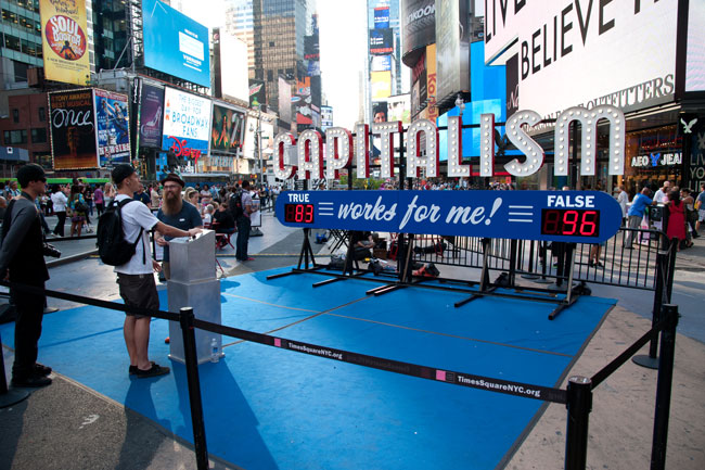
Steve Lambert, Capitalism Works For Me! True/False, 2011. Photo by Jake Schlichting.
In Imaginary Maps, Global Solidarities, Brian Holmes states that ‘every society has mental maps, patterns of movement which also assign people to their proper places. Political dissent implies the imagination of a different map, which gradually takes form by tearing itself away from the dominant ones’.[17] Steve Lambert’s Capitalism Works For Me! True/False (2011) uses real-time data to highlight the discrepancies between economic policy and the day-to-day experiences of ordinary citizens.[18] Installed as a large-scale billboard, the piece invites passersby to vote on whether capitalism is working for them. Installed in multiple cities as a lead up to the 2012 US election, the datasets generated through the piece serve as socioeconomic snapshots of both place and time, providing a critical counterpoint to the election process by gathering personal data in areas where people from different electoral districts, economic backgrounds, and political sensibilities collide. On March 7 of this year, the project became an even more literal example of sociopolitical critique when Bernie Sanders retweeted an article containing an image of the artwork.
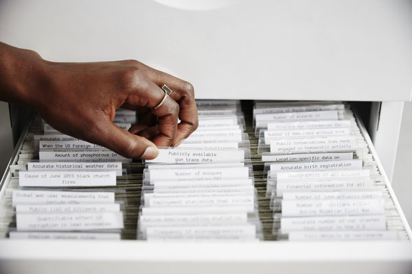
Mimi Onuoha, Missing Datasets, 2017. Image courtesy of the artist.
Mimi Onuoha’s Missing Datasets (2015–) is intended to draw attention to the blank spots ‘that exist in spaces that are otherwise data-saturated’.[19] Onuoha’s datasets highlight the correlation between missing data and spatial, social, and economic vulnerability by focusing on data that ought to be available, including: people excluded from public housing because of criminal records; trans people killed or injured in instances of hate crime; and statistics on how often police arrest women for making false rape reports. The project also examines the relationship between data collection and systems of power:
For every dataset where there’s an impetus for someone not to collect, there’s a group of people who would benefit from its presence. More data doesn’t always mean better answers, but in cases where data is used as the end-all tool of proof or a definitive measure for change, then it’s clear that lacking it can be a serious structural disadvantage.[20]
The project manifests as both an online data repository available via Github and as a gallery installation consisting of file cabinets filled with hundreds of labelled, empty folders.
In some instances, using data to draw attention to a political issue becomes a political issue. Last year, Sampson Wong and Jason Lam’s installations Our 60-second Friendship Begins Now (2016) and Countdown Machine (2016) were pulled down after just five days. Installed on the façade of the International Commerce Centre in Hong Kong, the piece was part of the Human Vibration exhibit, funded by the Hong Kong Arts Development Council. On the day of the opening the artists abruptly changed their installation from its original form (a scrolling dialogue from the Wong Kar-wai film Days of Being Wild) to a countdown of the number of seconds until the ‘one country, two systems’ framework is set to expire. The change was timed to coincide with an official visit from a member of China’s governing party, and was publicized by the artists through a massive media campaign.[21] Under pressure, the curators pulled the work. Tanya Toft from the University of Copenhagen described this work an act of both political and cultural urgency—political in that it marks the end of Hong Kong’s independence, and cultural in that it illustrated the ways that large-scale urban media risks surveillance and censorship.[22] In the same way that the fate of Richard Serra’s Tilted Arc embedded the work in cultural memory upon being torn down, the operative power of Countdown Machine may lie less with its content and more with its controversy. The countdown itself referred to the public countdowns in mainland China leading up to 1 July 1997, which appeared on billboards, television, and was recited daily by schoolchildren. It will be interesting to speculate how this work will hold up over time, both leading up to and following 2047.
In The Headmap Manifesto, published in 1999, Ben Russell predicted some of the social and cultural implications of new location-aware devices, envisioning a ‘new world’ where ‘everything gets tracked, tagged, barcoded and mapped’.[23] Written as a collection of fragments shortly after the announcement of the FCC E911 rules,[24] the text anticipated the impact of GPS-enabled mobile devices on geographic borders, sex and love (which would be ‘easier to find’), and real-world gaming.[25] In the same way that site-specific practice now operates within an expanded field that includes and embraces itinerancy, indeterminacy, and temporality,[26] similar shifts in locative media now suggest that our experiences ‘in place’ are shaped by interactions between situated systems of meaning. In From Mannerist Situationism to Situated Media, Tuters discusses the future of locative media following the ‘object turn’— ‘which sees objects as composed of networks of associations, a concept of cognitive mapping that goes beyond geography’.[27]
As location-awareness continues to develop and become standardized into our media devices and embedded into the environment, what emerges is a much more relational notion of proximity to objects. In addition to physically locating us in relation to them, objects become positioned in relation to one another, and crucially, they become represented as gatherings of issues, in relation to which we can formulate cognitive maps.[28]
The data generated through these systems in turn generate new systems that rely less on objects themselves and more on the intersections between themselves and other systems. The same holds true if we expand the field to include bodies—for example, relational data from online activity can be used to generate new products and services, to drive new business, or to improve the value of a neighborhood. This same data can be used to reinforce systems of spatial inequality. Borderline is a research-creation project of mine that examines the relationship between sound and socioeconomic divisions within cities using historical housing data, open data, and performance. The project combines archival research and critical mapmaking to create a mobile sonic artwork that generates personal ‘playable’ drawings in public space by ‘listening’ to everyday experience. As data becomes more integral to everyday life, our actions will occur within a new form of consciousness and a post-locative physicality, where we are everywhere and nowhere at once. Data-driven artistic practice provides an essential lens for understanding both the impact of algorithmic information on the social space of cities, but also a means for capturing subaltern methodologies.
[1] Tuters, Marc, and Kazys Varnelis. ‘Beyond Locative Media: Giving Shape to the Internet of Things’, Leonardo, 39:4, 2006, 357–63, http://networkedpublics.org/locative_media/beyond_locative_media, accessed 30 August 2011.
[2] Modes, Wes. ‘Listening Post Ten Years On: Revisiting the Technical Achievements of Listening Post Ten Years On’, NmediaC: The Journal of New Media and Culture, 9:1, 2013-14. http://modes.io/listening-post-ten-years-on/, accessed 1 October 2016.
[3] Hansen, Mark, and Ben Rubin. “Listening Post: Giving Voice to Online Communication,” Proceedings of the 2002 International Conference on Auditory Display, 2002.
[4] Micallef, Shawn, et al. Hear You Are—[murmur] Toronto, 2003, http://murmurtoronto.ca/, accessed 26 January 2016; House, Brian. Yellow Arrow, 2004, http://brianhouse.net/works/yellow_arrow/, accessed 25 January 2016.
[5] Tuters and Varnelis, 2006, 3.
[6] Polak, Esther, and Waag Society. Amsterdam RealTime, 2002, http://waag.org/en/project/amsterdam-realtime, accessed 1 October 2016
[7] Rueb, Teri. Drift, 2004, http://terirueb.net/drift/index.html, accessed 1 October 2016.
[8] Shuster, Aaron. Stanley Brouwn, 2005, https://frieze.com/article/stanley-brouwn, accessed 1 October 2016.
[9] Aceti, Lanfranco. ‘Meanderings and Reflections on Locative Art’, Leonardo Electronic Almanac, 21:1, 2016, 10.
[10] Silva, Adriana de Souza e., and Jordan Frith. Mobile Interfaces in Public Spaces: Locational Privacy, Control, and Urban Sociability (New York: Routledge, 2012), 119.
[11] Oliver, Julian. Border Bumping: In GSM We Trust, 2012-2014, https://borderbumping.net/, accessed 1 October 2016.
[12] Catherine D’Ignazio. It takes 154,000 breaths to evacuate Boston, 2007, http://www.kanarinka.com/project/it-takes-154000-breaths-to-evacuate-boston/, accessed 18 February 2017.
[13] Fusco, Coco. ‘Questioning the Frame: Thoughts about Maps and Spatial Logic in the Global Present’, In These Times, 2004, http://inthesetimes.com/article/1750/, accessed 1 October 2016.
[14] D’Ignazio, Catherine. ‘What Would Feminist Data Visualization Look Like?’ MIT Center for Civic Media, 2015, https://civic.mit.edu/feminist-data-visualization, accessed 20 October 2016.
[15] Warren, Gwendolyn. ‘The Geography of the Children of Detroit’, Detroit Geographical Expedition Institute Field Notes, Discussion Paper 3, 1971.
[16] Wood, Denis, and John Krygier. “Maps and Protest,” in International Encyclopedia of Human Geography 1 (2009), 438.
[17] Holmes, Brian. Imaginary Maps, Global Solidarities, 2000, https://brianholmes.wordpress.com/2000/10/20/imaginary-maps-global-solidarities/, accessed 1 October 2016.
[18] Lambert, Steve. Capitalism Works For Me! True/False. September 2011, https://visitsteve.com/made/capitalism-works-for-me-truefalse/, accessed 20 January 2016.
[19] Onuoha, Mimi. Missing Datasets Github, 2016, https://github.com/MimiOnuoha/missing-datasets, accessed 1 October 2016.
[21] Qin, Amy. ‘A Subversive Message in Hong Kong Goes Up in Lights’, The New York Times, 2016, https://www.nytimes.com/2016/05/19/world/asia/hong-kong-2047-countdown-icc.html, accessed 1 October 2016.
[22] Toft, Tanya. ‘The Search: Inquiries of Urgency in Urban Media Art and Aesthetics’, Presentation at the 2016 Media Architecture Summit, Toronto, September 29–October 1, 2016.
[23] Russell, Ben. Headmap Manifesto: Know Your Place (Location-aware Devices), 1999, http://web.archive.org/web/20020731094715/www.headmap.org/book/pdf/headmap-manifesto.pdf, accessed 15 March 2017.
[24] The Federal Communication Commission’s ‘Enhanced 911 services’ required that wireless providers provide the coordinates of phones within its service areas in order for emergency services to be able to locate calls automatically rather than relying on the caller to know where they are. These rules drew sharp criticism from Jason Dempsey of the Center for Democracy and Technology, and an article entitled ‘E911 Turns Cell Phones into Tracking Devices’ appeared in Wired Magazine.
[25] Given last year’s hype around Pokémon GO, it feels timely to highlight Russell’s speculation of a world where ‘you had to run around and climb things to play computer games rather than sitting in a room listening to headphones’: ‘Imagine games which involved spatial challenges, and involved whole communities of kids, both building the levels and playing the games. / “go to the end of the road and climb on the roof of the deserted cinema” / or rather (introducing a time element, and in order to get the next instruction) / “RUN to the end of the road and climb on the roof of the deserted cinema.” / Such games might result in a few fatalities, but at least it would get kids out of the house’ (Russell, 1999, 25).
[26] Kwon, Miwon. One Place After Another: Site-Specific Art and Locational Identity (Cambridge, Mass.: MIT Press, 2012), 3.
[27] Tuters, Marc. ‘From Mannerist Situationism to Situated Media’, Convergence, 18:3, 2012, 271.
Jessica Thompson is a media artist working in sound, performance and mobile technologies. Her practice investigates the ways that sound reveals spatial and social conditions within cities, and how the creative use of urban data can generate new modes of placemaking and citizen engagement. In 2017, she received a SSHRC Insight Development Grant for ‘Borderline’, a research-creation project that investigates the role of sound in community formation, particularly in areas undergoing rapid social change.
Her work has shown in exhibitions and festivals such as the International Symposium of Electronic Art (San Jose, Dubai, Vancouver), the Conflux Festival (New York), Thinking Metropolis (Copenhagen), (in)visible Cities (Winnipeg), Beyond/In Western New York (Buffalo), New Interfaces in Musical Expression (Oslo), Audible Edifices (Hong Kong), Artists’ Walks (New York) and Locus Sonus (Aix-en-Provence), as well as publications such as Canadian Art, c Magazine, Acoustic Territories, and the Leonardo Music Journal. She has received grants from the Ontario Arts Council, the Toronto Arts Council, and the Social Sciences and Humanities Research Council. She is an Assistant Professor in Hybrid Practice at the University of Waterloo.